

The featured image comes from the booklet prepared for the 90th birthday celebration of Charles Bathurst 1st Viscount Bledisloe of Lydney in 1957. Copyright for the image, and for some others in this blog, is held by G.K. Davis of Bream in Gloucestershire (www.sungreen.co.uk). Details of the career of Lord Bledisloe can be found at …
https://en.m.wikipedia.org/wiki/Charles_Bathurst,_1st_Viscount_Bledisloe
The image shows the extensive nature of the railway infrastructure at the Harbour. All of this has now gone!
Lydney Harbour and its Transport Links
From Roman times through the industrial revolution and well into the 20th century Lydney Harbour has had a significant place in the heritage of the River Severn and its estuary.
The estuary has a massive 48ft tidal range, is an internationally important wildlife habitat and has had a major impact on the prosperity of Great Britain as one of the UK’s principle sea links to the rest of the world.
Lydney Harbour was a prominent local harbour for coal, iron ore and other commodities and integral to the economy of the South West over centuries.
Easy access to the estuary resulted in Lydney’s importance as a trading centre and a harbour was built to transport iron and later coal from the forest. The harbour was originally the last port on the Severn where sea-going boats could unload. Where the River Lyd flows into the estuary was known as Lydney Pill. However, the silting up of the local river closed the old harbour and a new wharf had to be built. With the charcoal iron industry and coal production thriving and roads through the forest remaining poor, Pidcock’s canal was constructed from 1790 onwards, connecting Upper and Lower Forge at the head of Lydney Pill.
The current canal and basin complex was built by the Severn and Wye Railway and Canal Company between 1810 and 1813. A horse drawn tramway was laid, to move the coal and iron to the wharves after it was brought down from the pits and forges on the Pidcock’s Canal. The new dock on the estuary was started in 1809 and opened in 1813. The outer harbour was finally completed in 1821.


During the hey-day of the harbour there was around 300,000 tons of coal being exported annually in over 2000 vessels. The final export of coal from the harbour was in 1960.
 In the 1960s imported wood was still being brought in by barge from Avonmouth. It remained in commercial use until the 1970s. The entrance to the canal consists of an outer tidal gate opening into a wide basin. From there a lock opens into the one-mile canal cut. Immediately above the lock, a pair of gates point the other way as protection against a high tidal flood in the estuary. There is one swing bridge crossing the canal.
In 1985 the harbour from the swing bridge downstream was scheduled as an ‘Ancient Monument’, due to the historic importance as a transport link for the Forest of Dean to the Severn. The swing bridge was designated a Grade II Listed Building in 1988 due to it being ‘a very good example of the direct and sturdy quality encountered in the functional tradition of quay-side design’.
As the last major alterations to the harbour were conducted during the 1870s, Lydney is a rare example of an unspoilt 19th century harbour, built to accommodate sailing ships so its historic importance is disproportionate to its size.
In 1998 the Lydney Docks Partnership was established to create a sustainable future for the Harbour. In 2003 they secured from the Heritage Lottery Fund £873,000 towards restoring the docks. This was supplemented by further funding from the Environment Agency, English Heritage, Gloucestershire County Council, Forest of Dean District Council and Lydney Town Council.
As part of the reconstruction process archaeologists recorded evidence of the docks’ historic use. The results of this work have provided an important insight into how the harbour functioned in the Nineteenth century.
The archaeological work has helped define the historic value of the surviving standing buildings on the site. Additional landscaping works have taken place to improve disabled access and address public safety issues.
On the 23 July 2005, Lydney Harbour was re-opended after a two year restoration project. Restoration included:


Restoring and enhancing flood defences running along the side of the dock.
The installation of four custom-made automated metal-gates and associated mechanisms, in the outer dock and inner harbour. These replaced the older, dilapidated hand-operated timber gates.
Dredging of the dock and harbour to remove several tonnes of silt (and the odd wrecked car) which had accumulated over the years.
Full refurbishment of dressed stonework on the walls and the floors of the docks.
Improving access for all.
Additional landscape works.
Timeline
1809 – The Lydney and Lydbrook Railway Act enabled construction of a tramroad from Lydbrook to Lydney.
1810 – A second act changed the company name to the “Severn & Wye Railway and Canal Company” and (amongst other things) authorises the building of the canal to the River Severn at Nass Point.
1810 – Josias Jessop (son of William Jessop) was appointed consulting engineer and designed plans for the canal.
1811 – Thomas Sheasby (son of Thomas Sheasby senior) was taken on as resident engineer.
1813 – The canal was opened by the Severn and Wye Railway and Canal Company.
1821 – The outer harbour was finally completed and the tramway extended all the way down.
1825 – The north pier was extended to aid ships into the harbour.
1868 – The tramway was converted to broad gauge.
1872 – Converted to standard gauge.
1893 – Severn and Wye Railway and Canal Company went bankrupt.
1894 – Purchased by the Great Western and Midland Railways and administered by a Joint Committee of the two companies.
1948 – The railway and docks passed to the Western Region of the Railway Executive on nationalization.
1950 – Transferred to the Docks and Inland Waterways Executive.
1960 – The last coal was shipped from the harbour.
1977 – The harbour was closed.
1985 – The section from the swing bridge to the Severn was scheduled as an Ancient Monument
1988 – The swing bridge was scheduled as a Grade II listed building.
1996 – The Environment Agency took over management of the docks.
1997 – Inner gates collapses and had to be replaced by a dam to reduce flood risk.
1998 – The Lydney Docks Partnership was established to create a sustainable future for the canal.
2005 – Re-opened after a two-year project of restoration and enhancement.
Pidcock’s Canal
 Pidcock’s Canal was a canal in Gloucestershire, England, which connected ironworks at Upper Forge and Lower Forge, and also ran to an inlet from the River Severn called Lydney Pill. It was constructed from 1778 onwards[4], and there were three locks below Middle Forge. Following the construction of the Lydney Canal in 1813, the canal connected to that, rather than Lydney Pill, and it was disused after 1840, by which time a horse-drawn tramway had been built up the valley of The Lyd. The tramway was eventually relaid as a steam railway and is now preserved as the Dean Forest Railway. Most of the canal, colloquially called The Cut, still exists below Middle Forge.
Large parts of the parish of Lydney were organised as an estate, which had been managed by the Bathurst family since 1723. The estate contained mineral reserves, and they profited from this by building ironworks. The Lower Forge ironworks were supplied with water by several streams, which were augmented by a long leat which left the Newerne stream near the Chepstow road.[5]
In 1775, David Tanner from Tintern was granted a lease of the Upper Forge, on the northern borders of Lydney. A new 99-year lease was negotiated in 1778, which included powers to construct a canal from there to the Lower Forge. It is known that the canal had been built by 1790, although the precise date of construction is unknown. Tanner sold his lease in 1789, and in 1790 it was sold again to members of the Pidcock family, who were glassmasters from Staffordshire. The Pidcocks managed the forges until 1813, when the lease was sold back to the Bathursts. They also had coal mining rights, and transported coal to Lydney Pill using the canal. On surrender, the lease covered the Upper and Middle Forges, the Lower Forge and rolling mill, the White Cross furnace, and the canal, which had by then been extended to Lydney Pill. John James took on the lease from 1814, building another forge at New Mills in the 1820s, and using the Lower Forge as a tinplate works from 1844. In 1889, Richard Thomas, who had leased the works from 1876, made improvements to the Lower Forge tinplate works, and the remaining works were stripped and abandoned.[5]
The Lydney and Lydbrook Railway (tramway) was authorised by an Act of Parliament in 1809. This became the Severn and Wye Railway and Canal in 1810 and construction of a tramway and canal to Lydney Harbour commenced in the same year. The tramway ran parallel to Pidcock’s canal as it followed the course of the Newerne Valley.[5] Pidcock’s Canal fell into disuse in the 1840s.[6]
The canal started at the Upper Forge, and ran close to the Newerne stream, also called The Lyd. The lower section took a more direct route to the Lower Forge, using the course of the leat which had supplied the works with water.[5] There were three locks near the Middle works.[7] The canal crossed the Chepstow road between Lydney and Newerne, and the branch from the Lower Forge to Lydney Pill was quite short.[5]
In 1880, the Upper Forge, New Mills and Middle Forge all had extensive ponds upstream of the works, contained by stone dams. Once the canal closed, the ponds covered its route between Upper Forge and Middle Forge. Ordnance Survey maps for the period show weirs and sluices at the downstream ends of the ponds, and the central one at Middle Forge appears to feed the canal. By 1880 there was no obvious route around the dams, and there is no mention of locks to allow boats to move between levels. As on modern maps, the canal was known as The Cut at the time. From the Lower Mill, the canal formerly ran to Lydney Pill, but the waterways were altered as a result of the construction of the Lydney Canal. The 1880 map shows two channels below the Lower Mill, one clearly joining the bottom of The Lyd, before it discharges into the Lydney Canal, and the other running from the reservoir on the upstream side of the works to a wide basin near the Lydney Canal, but with no obvious connection between them. Halfway along this section is a small branch which ends just south of Station Road Cottages.[5][8]
Tramways and Railways
 In the late 18th and early 19th centuries, a network of horse-drawn tramroads developed in the Forest of Dean, to transport coal and ironstone to the local ironworks, and, following the development of docks on the Severn at Bullo Pill and Lydney, to ship coal and other Forest products to markets further afield. With the introduction of railways to the Forest, beginning in the mid-nineteenth century, the tramroads were progressively superseded, in places physically overlaid, by the new transport system, though some continued as feeders to the railways well into the 20th Century. Many traces of the old tramroads remain, sometimes as footpaths following a trackbed, or as remains: stone sleeper blocks, earthworks, bridges and other structures.[9]
The Severn and Wye Tramroad, engineered by Roger Hopkins for the Severn and Wye Railway Co. opened in 1810. It ran from Lydney to Bishopswood with several branch lines linking it to collieries and ironworks. Various parts of the tramroad were absorbed into the Severn and Wye and Severn Bridge Railway from 1868 onwards. Also the Lydney and Lydbrook Railway, was incorporated in 1809 and completed 1812, it connected the Severn with the Wye, with many branches serving collieries, iron works, and other enterprises. Steam traction was introduced, in 1864. The original tramroad is not readily discernible except at points where it deviated from the railway which replaced it. The numerous branch lines are more easily traced and stone block sleepers are common.
Plans for a tramroad to link the mines of the west part of the Forest with the Severn at Lydney and the Wye at Lydbrook were under discussion from 1799, and an Act of 1809 authorised a line. A further act of 1810 renamed the project the Severn and Wye Railway and Canal and gave powers for a tramroad to a place just south of the head of the Lydney Pill and for a harbour in the form of a short canal. The line was built by a partnership including John Protheroe and bother local industrialists. It was completed in 1813 and followed the course of the Cannop Brook in the west part of the Forest and included a tunnel at Mirystock. Several branches were laid down by the tramroad companies but most were laid down by mine and quarry owners. The company provided early branch lines to serve mines and quarries in the slades west of Cannop Brook and built a line from the top of the Lydbrook incline down to the Wye at Bishopswood. Steam locomotives ran on the tramroad in 1864 and a broad gauge line was opened alongside the tramroad between Lydney and the bottom of Wimberry Slade in 1869 and in 1872 a standard gauge loop line was completed. Beginning in 1872 the Severn and Wye constructed a standard gauge railway from Lydney to Bilson and Lydbrook. When the railway was laid on or alongside the tramroad much of it was abandonned. A short section remained open fgor a time to serve Lydney tinplate works and a number of branches remained active well into the 20th Century.
There were 12 branch tramroads, including the Mirystock-Lydbrook-Bishopswood section and the privately owned Oakwood and Dyke’s branches. In addition scores of sidings and short branches served particular mines, quarries and works. Traces of most of the branches remain rarely being disturbed by the later railways. With the exception of the Churchway branch (and possibly Moseley Green), the tram locomotives did not serve the branch lines, being too steep and torturous. Various proposals for converting the branches to railways met with little success and they were gradually superseded by adjacent railway routes or abandoned. Three branches however, Bixslade, Howlers Slade and Wimberry Slade, remained in use into the 20th century.[10]
Prior to the construction of the harbour, the tramroad ran down to Lydney Pill by a temporary railroad. Once the outer harbour was completed in 1821, the tramroad was extended along the north side of the canal and a branch ran across to a new wharf on the west side of the harbour was added in 1823.[10]
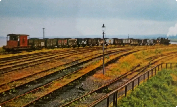 The railways which replaced the tramroads became increasingly complex throughout the late 19th and early 20th centuries. By the 1950s things were very different. The rows of wagons at Lydney harbour replaced by empty sidings as tge picture above shows. It comes from reference 3 below. Most of the railway infrastructure has now vanished leaving behind a heritage of earthworks bridges and tunnels which now provide a cycling and walking infrastructure in the Forest.The areas in the photograph above is now a wildflower meadow and a place to stroll enjoying views of the Severn estuary.


References
1. http://www.lydney-online.co.uk/local-information/lydney-history/lydney-docks
2. https://en.m.wikipedia.org/wiki/Lydney_Canal
3. Neil Parkhouse (2015). ‘British Railway History in Colour – Volume 2 – Forest of Dean Lines and the Severn Bridge’, Lightmoor Press, Lydney, Gloucestershire.
4. Gloucestershire County Council Archives.
5. Currie, C R J; Herbert, N M, eds. (1996). A History of the County of Gloucester: Volume 5: Bledisloe Hundred, St. Briavels Hundred, The Forest of Dean. Victoria County History. British History Online.
6. Jim Shead, Waterways History, Pidcock’s Canal
7. Paget-Tomlinson, Edward W. (2006). The Illustrated History of Canal & River Navigations. Landmark Publishing. ISBN 1-84306-207-0.
8. Ordnance Survey, 1:2500 map, 1880.
9. Tony Youles. Tramroad Remains in the Forest of Dean: https://scholar.google.co.uk/scholar?cluster=317656453150696705&hl=en&as_sdt=0,5&sciodt=0,5.
10. http://www.heritagegateway.org.uk/Gateway/Results_Single.aspx?uid=4329&resourceID=108

Found your research of the area fascinating. We enjoy the area and its industrial history.
Pingback: Forest of Dean Visit – The Railway Dog
I found this to be very interesting but only managed to visit the Forest of Dean in the late 1950’s
The Forest will have changed immeasurably since then! Well worth a visit!
Pingback: The river placename Pill – a context - Waterford Harbour Tides & Tales