

Toulon-Hyères
Details of the Chemin de Fer du Sud de la France from Toulon to Saint-Raphael are culled from a number of sources. Three significant ones are: Roland Le Corff [1], Marc Andre Dubout [2] and Jean-Pierre Moreau [3]. Others will be referred to as we follow the route of the line.
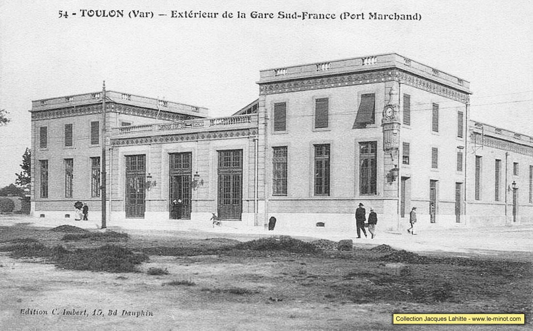
 The Station in Toulon was in an attractive location close to the waterfront. Sadly it has been completely demolished and the land developed. To help in identifying locations along the line we will work on Toulon Station being at kilometre point zero. The district of Toulon where it was situated is La Rode. And its site is now that of a school – Dumont d’Urville high school. The station site included a good shed, an engine shed for stabling up to four locomotives, three goods sidings, four passenger platform lines, a 120 cubic metre water tower and two hydraulic cranes. Two excellent images show the location of the station in relation to the water front. The lower, line-drawn image shows the sidings of the Chemin de Fer du Sud which left the main line just 50 metres from the station throat and provided direct access to the quay side.


The next two images from the website maintained by Jean-Pierre Moreau not only give a really good impression of the layout of the station at Toulon. They also show clearly the changes in Toulon since the station closed.


The station was a handsome building, as the next early image shows. On the northwest corner of the building there was a double-faced clock which allowed the time to be seen all over the area of the Port-Marchand.
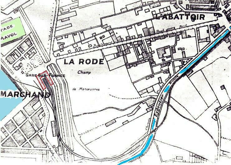
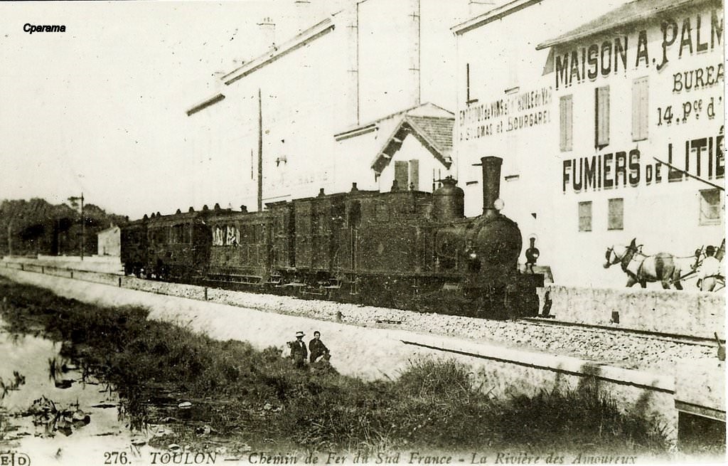
 In the adjacent plan (dated 1926) the Station building (1) sits alongside the freight branch to the dockside (2) The repair shop (3) is 70 metres or so from the Station building. The water tower is next to the engine shed (4); the track bends sharply (5) then and crosses the bridge over the Eygoutier River (6). The River Eygoutier is also known as the River Amoureux.
Before we leave Toulon’s Gare du Sud behind we need to confirm one thing which impacts the layout of La Rode and which means that the original position of the station now appears much further from the quay side of the port. Bombing in WW2 devastated the port. Post war rebuilding saw areas of the dock reclaimed. The harbour is now significantly altered in layout compared with its pre-war condition. This leaves the station site further from the quay than it was before WW2.
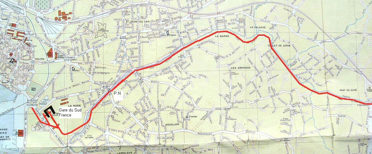
 After the railway had crossed the river it followed the river bank on the southern side of the river for a little under a kilometre where it crossed Ligne 7 (La Gare to Cap Brun-Magaud) of the tramway network at Le Pont de l’Abattoir by a level crossing. This is marked with a blue line on the right side of the map above. A halt was opened here in 1937.
 It travelled on towards St-Jean-du-Var (a halt opened here at the same time as Toulon Gare du Sud) and on through La Barre, La Palasse, Collet de Gipon, Armeniers and Pont-du-Suve. Halts were opened in 1905 at both Armeniers and Pont-du-Suve and in both cases the buildings still survive.
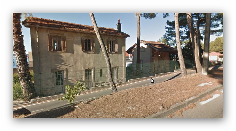
The buildings at Armeniers and Pont-du-Suve are typical of the small buildings which were present at halts in the suburbs of Toulon. Armeniers halt was just over 3 kilometres from Toulon Gare du Sud. It is now a private house. The image comes from Google Streetmap.
From the immediate suburbs of Toulon to Le Pradet, the route of the old railway has been converted into a cycleway which follows the River Eygoutier. The aerial view at Pont-de-Suve (4.4 kilometres from Toulon Station) shows both the cycleway and the halt building.
At Le Pradet the cycleway on the formation of the railway runs directly alongside the D559 (Avenue General Brosset). Two shots of the cycleway looking abck towards Toulon are followed by a picture of Halt at Le Pont Clue on the way into La Pradet and shows the cycleway in the foreground alongside the D559 road. We are now 6.3 kilometres from Toulon Station! The next halt is just before entering La Pradet at what was called Les Gravettes (and now-a-days is known as Les Gravettes-Pin-de-Galle). Opened in 1905, the building still exists.


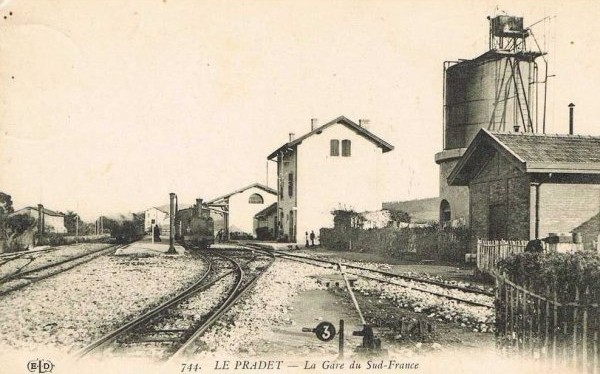
 8.7 kilometres from The Gare du Sud in Toulon we arrive at La Pradet Station. It was a more significant stop on the line with passenger facilities, a goods shed, two goods sidings, a passing loop serving two platforms, a 50 cubic-metre water tower and three hydraulic cranes. The Station building still exists, converted into housing it sits close to a cultural centre – “Espace des Arts”, effectively enveloped by it! Little else of the site remains. The first image was taken in 2004 by Jacques Lahitte. The second modern image was taken from Google Streetview in 2017.

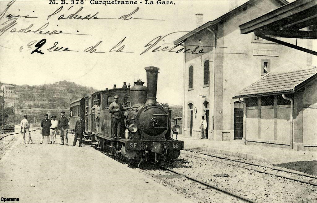
 Three old postcards give a reasonable impression of the station in its heyday!
It was an important station on the line because it provided a loading point for copper ore. In 1950, the station was purchased by the municipality to form a girls’ school.
Leaving La Pradet the railway formation followed the D559 road and now-a-days continues to be used as a dedicated cycleway. Halts were opened with the railway line at La Bayette, La Moutonne and La Colle-Noire.
At La Colle-Noire a short branch left the Chemin de Fer du Sud mainline to provide a rail link to a mine at Cap Garonne – a copper mine.
The branch-line to the Cap Garonne copper mine was 4 kilometres long. It left the mainline between La Moutonne and La Colle-Noire and allowed the transport of copper ore to Toulon. The line was steeply graded and was, from 1907 equipped with the Hanscotte system. The engineer Jules Étienne Hanscotte developed a system to ensure the stability of the train with horizontal wheels in pressure against a central rail it allowed trains to adhere effectively one grades much steeper than normal. The most well-known application in France of the Hanscotte system was the Puy de Dôme tram, which ran from 1907 to 1926.
The Cap Garonne mine was opened in 1873. It was in English hands from that date until 1884. It was owned by John Morley Unwin. It employed about 40 workers during this time. Ownership was transferred to a Mr. Roux after a period in liquidation. He owned the mine from 1892 to 1899. At that time, a small factory was built at the mine for manufacture of copper sulphate from poor quality arisings. The mine was in operation until 1917, served by the branch from 1906 onwards.
 The approximate route of the branch is shown on the adjacent extract from the 1930s Michelin map of the area.
The branch left the mainline adjacent to these modern greenhouses and followed a straight path across relatively level ground, before wandering around La Colle-Noire.

The satellite image from Google Earth allows the route of the line to be identified quite easily. In the image below, the route runs diagonally from the North-east to the South-west. In the smaller image the route runs from the middle-top to the mine location at the bottom of the image.


These images show that it is easy to identify the line the immediately following image picks out that line. It comes from the website of Jean-Pieree Moreau.

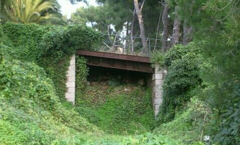
 Marc Andre Dubout provides a few images to help us identify with the area. The first is this accommodation bridge.
The second image shows the factory. He comments that this second image is an overview of the mine and factory now transformed into a museum, with the railway passing immediately behind the buildings.

There are other images which can be found on the internet and some of these follow here. Hopefully they will give a good indication of the size of the operation.
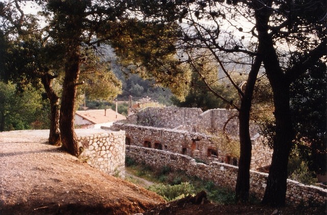


As noted above, the mine closed in 1917 and was only in use after that for a short time as a mushroom farm (1946-1953) before the museum was opened in 1994.
In the years after 1953, the galleries remained open and the mine was looted. Even though the mine was no longer commercially viable for the extraction of copper, it still retained an extraordinary richness of mineral deposits. It was and is host to over 100 different minerals of significant scientific interest. By 1984, environmental considerations and the need to preserve the integrity of the site for heritage purposes resulted in local authorities protecting the site. The mine was situated in the heart of a forest of 300 hectares of significant scientific interest. The three communes that owned the museum formed an inter-communal syndicate which took the decision to close all accesses to the mine to prevent looting in 1990.
The communes of La Pradet, La Garde and Carqueiranne took the shared decision to create a museum at the site. The museum opened in 1994. Displays inside the museum aid in understanding the operation of the mine, give good examples of the minerals which have been extracted within the mine and enable visitors better to understand the mineral composition of ground rocks in the area.
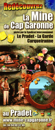 The brochure says: “In the heart of a unique forest overlooking the Mediterranean, the old copper mines of Cap Garonne are among the five most beautiful mineralogical sites in the world. The diversity, the richness, the scientific interest of the identified crystals attract researchers from all over the world. This is the only French museum of copper and micro-minerals. It reveals how humanity has used copper over time, the place that copper has held in our daily lives, how the mine has changed with the changes of civilization, the current uses of copper. In addition, visitors will have a fantastic journey to the heart of the earth. From the life of the miners to the history of the rock, the visit of the mine is a living lesson, a fascinating adventure for young and old.”
The branch-line junction was controlled by means of a ground-frame contained in a small wooden cabin and telegraph apparatus enabled the branch working to demand access onto the mainline for access to the sidings at La Pradet. Once the mine had closed in 1917 there was little need for the branch, however, it does not seem to have been formally closed until 1928 and the track was not lifted until 1930.
Beyond the Cap Garonne branch-line, the modern D559 by-passes the centre of Carqueiranne and to do so it follows the formation of the old railway main-line. A cycleway has been built alongside the by-pass but the formation is hidden under the main carriageway.
About 12 kilometres from Toulon Station a small halt was opened in 1937 at Paradise.
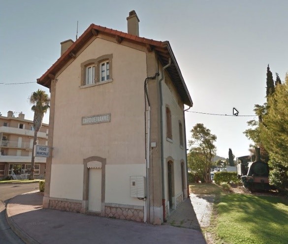
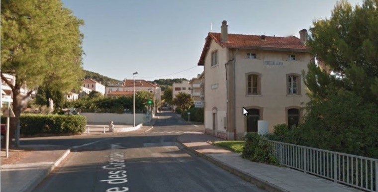

 Carqueiranne Station is reached just over 14 kilometres along the railway from Toulon Gare du Sud. It opened in 1905 had had a similar status to the station at La Pradet (3rd class with a goods shed, two main tracks and a good siding). Today, the station houses the police offices. The locomotive which can be seen adjacent to the station is a reminder from the municipal authorities of the historic use of the site. It is, however, misleading.

The locomotive is a 0-4-0 built in 1921 by Henschel & Sohn in Kassel, Germany. It was given the number 18524 and was sold to the F. Béghin sugar refinery at Thumeries (North). It was never used on the Cap Garonne branch, nor on the Chemin de Fer du Sud. It is a standard gauge locomotive and the lines we are interested in are metre-gauge.


I love looking at these old postcards. I don’t know what that is really all about. Perhaps it is nostalgia. But it is more likely to be something to do with fascination for what things used to be like. There wasn’t anything better about those times, but they were different. They were times of amazing progress, but still times of poverty and inequality.

Leaving Carqueiranne, the Chemin de Fer du Sud followed the coast-road through two halts, one at Beau Rivage and Fontbrun. Just before arriving at San Salvadour, 16.1 kilometres from the Gare du Sud, the formation passed in tunnel under the D559 and emerged on the right-hand side of the road.

The tunnel was 284 metres long and on a curved alignment. The postcard below is taken looking through San Salvadour Station towards the Eastern portal of the tunnel.

16.5 kilometres from Toulon Station we arrive at San-Salvadour – Mont-des-Oiseaux Station. This station was of greater importance than earlier ones on our journey. So much so that at the formal opening of the line this station played a significant role. The inaugural train stopped at the station on 6th August 1905.
The station opened with the railway in 1905, it qualified as a 2nd Class Station and the passenger facilities were slightly improved over those we have seen on the line since we left Toulon. There was a good shed, as can be seen above, two platforms served passengers and there was a goods siding as well. The two remaining buildings – the passenger station building, and the goods shed – are used as outbuildings by the nearby hospital. They can be seen alongside the D559 not far from the sea-shore. The railway formation continues to be used as a cycleway close to the road. Below the photograph of the station buildings today there are a sequence of photos, of trains arriving, from St. Raphael, at San Salvadour Station.


These last two postcards show two of the more significant buildings close to the station – the first is the marine hospital/sanatorium of Du Monts des Oiseaux, the second is the Grand Hotel and the Chateau.

The two remaining station buildings are at the centre of the satellite image above.
As we leave San Salvadour Station the line heads eastwards for a short distance before sweeping in an arc away from the coast and heading north towards Hyeres, passing through a small halt at L’Almanarre-Pomponiana (L’Amanarre before 1911), 18 kilometres from the start of our journey. San Salavdour Station is marked ‘A’ on the aerial photograph below and L’Amanarre Halt is marker ‘H’.

L’Amanarre Halt is notorious for a bad accident which happened here on the line in 1911. However, all evidence of the Halt is buried under the modern roundabout junction between the D559 and the D42 roads.


Travelling north from this location the railway formation closely followed the modern D559. Once again, a cycleway runs alongside the road on the approximate line of the railway formation. Before arriving at Hyeres, the railway passed through three more halts at Costebelle, Le Palyvestre and Les Nartettes and then passed under the PLM line from Hyeres to Les Salins d’Hyeres.

After the under-bridge, the line arrived at an interesting triangular junction formed when the mainline from St. Raphael was extended to Toulon. The original terminus of the line, close to the PLM station became a lesser station and gradually changed into a trans-shipment location for goods.
Jean-Piere Mareau has pulled together plans of the area and ariel photographs and imposed these onto satellite images from Google Earth. The resulting images are of great interest.
First, we see the aerial image of the route of the Chemin de Fer du Sud and the triangular junction which interestingly picks up a number of goods wagons on sidings on the PLM line.

The second image is a composite satellite and aerial image which shows both the PLM Station and the Chemin de Fer du Sud transhipment wharves. Both stations show evidence of significant amounts of good traffic.

This close up of the aerial image shows the PLM station the station square, the hotel ‘Terminus des Deux Gares’ (marked with the arrow) and the Chemin de Fer du Sud Hyeres Echange Station (marked with the tag).

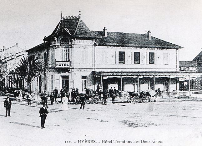
In the image which shows the full elevation of the hotel, the terminus building for the Chemin de Fer du Sud can just be picked out on the far right of the photograph. The hotel and the terminus building have long-gone and have been replaced by modern development.
Moreau’s final contribution at this site is, for me at least, the most interesting. He has overlaid a hand-drawn plan of the Hyeres Echange Station onto the modern Google Satellite image. The composite image is shown below. It sows clearly the complexity of the track layout and a sense of the importance of the station. The Station opened in 1890 and was the terminus of the line from St. Raphael before the extension to Toulon was built. It had passenger and goods facilities, an engine shed which could house 4 locomotives, two platforms for passengers and three main goods sidings. In 1900, longer goods transhipment sidings were installed. In 1907, modifications were made which focussed on good transhipment at the station.

 Travelling on from the triangular junction, after a short deviation to the North-east, the line continues North, a hundred metes or so to the east of the D559 before turning North-east again and entering Hyeres Station. This is the end of this part of our journey.
References
[1] Roland Le Corff; http://www.mes-annees-50.fr/Le_Macaron.htm, accessed 13th December 2017.
[2] Marc Andre Dubout; http://marc-andre-dubout.org/cf/baguenaude/toulon-st-raphael/toulon-st-raphael1.htm, accessed 14th December 2017
[3] Jean-Pierre Moreau; http://moreau.fr.free.fr/mescartes/ToulonGareSudFrance.html, accessed 24th December 2017.
[4] José Banaudo; Histoire des Chemins de Fer de Provence – 2: Le Train du Littoral (A History of the Railways of Provence Volume 2: The Costal Railway); Les Éditions du Cabri, 1999.
