

 This final length of our journey takes us along what is now the defunct line to Kasese. The first part of this line in the Kampala suburbs still exists but further west there are only remnants of the line. In 1994, I attempted to travel to Kasese and I might have been able to do so if I was prepared to wait in Kampala for the possibility that a train might run. In the end my trip to the South West of Uganda was much better served by a road journey via Masaka, Mbarara and Kabale.
The picture above shows one of those sporadic passenger trains to Kasese which in the end I missed! [1]
The Western Extension, as it was known, was built and opened in the mid-1950s, its main target was to reach the Kilembe Copper Mines in the west of Uganda. Kasese was built alongside the Mines and has grown since then into a reasonable size town with industry and tourism building its economy.
Official sanction for building the railway to Mityana was given in 1951, and for the continuation to Kasese in 1952. The decision rested upon a guaranteed source of traffic at Kilembe, and was prompted by the fact that mining development was dependent on some positive step to improve communications. There seemed little doubt that the line would attract some Congo traffic, which would provide new revenue for E.A.R. & H., while the Uganda Government was much encouraged by the very favourable report of an Economic Survey Committee. The concluding sentence of the report reflects the tone of the whole: ‘The committee desires to record its firm conviction that this project will prove eminently successful. and contribute materially to the welfare and prosperity of the people of Uganda”. The capital cost of the extension was £5.25 million, and the Uganda Government provided the Railway Administration with a loan to cover this. The government also guaranteed to meet any operating losses incurred on the line, although the chances of such losses were reduced by the policy of crediting to the line any profits on traffic also passing over the Kampala-Mombasa section. [9]
In the last post we left Kampala Railway Station and travelled the very short distance into the suburbs to Nalukolongo, the main workshops for the Railway system in Uganda. To be reasonably sure of getting a passenger train towards Kasese we would probably need to go back to the mid 1990s, and even then we probably need to be ready to leave within a week of our intended journey date and expect to take at least 36 hours on the journey. Back in the heyday of the line the journey to Kasese could be achieved overnight with an evening departure from Kampala and a morning arrival in Kasese.
OpenStreetMap when accessed in 2018 showed the railway extending only to Nalukolongo. Later we will see that the approximate route through to Kasese often appears as a dotted line on OpenStreetMap.
Beyond Nalukolongo, the line is shown on OpenStreetMap as a short stub serving industrial premises to the West of the Lubigi Channel. The mainline bridges the channel before becoming disused. A spur enters the premises of Ntake Bakery Co. Ltd. and a further short spur serves Roadmaster Cycles premises.
Google Maps shows the route of the old line to Kasese. The route runs to the south of the Lubigi Channel past the Kabawo Market and on through the Kampala suburbs, until it crosses the Masaka Road southwest of Busega. Continuing in a westerly direction, the line passes to the south of Buloba and then turns North-west before reaching the halt at Bujuko, 28 kilometres from Kampala Railway Station. The probable location of the halt is on the right of the satellite image below, adjacent to the Kakiri-Bujuko Road.
 The next halt is at Kawolongojo, according to the adjacent map. There is a primary school of this name close to the route of the railway and it seems most likely that the satellite image below shows the location of the station.
 The next stop is at Mityana. The station is shown on the adjacent satellite image, the railway route is just about visible running from bottom right to top left of the image. On the map below, the station location is marked by the blue square.

When the route of the line was planned in the 1950s a full survey had already been undertaken of the route from Kampala to Mityana some years before. The route beyond Mityana was a matter for debate. The railway could either follow the Katonga valley or pass further north through Mubende. The exact terminus was also a matter of debate, although the line obviously had to pass as close as possible to Kilembe. The 1930 survey committee had recommended a route via Mubende in order to serve that District most effectively, but in the 1951 report this was rejected as being unduly costly, and approval was given to the Katonga route. This provided the most direct link between Kampala and Kilembe. and was expected to provide a service for Ankole as well as Mubende. After reaching Mityana in 1953, the line was therefore extended to Musozi in 1954 and Nkonge in 1955. Four possible termini were considered, out of which Kasese, that involving least expenditure, was finally chosen. The rejected proposals were for extensions beyond Kasese 8 miles to the western arm of Lake George, 22 miles to the Kazinga Channel or 31 miles to Lake Katwe. The country offered few problems for construction, yet the cost of each proposal (£0.1, £0.4, and £0.55 million respectively) was considered too high in relation to the probable benefits. The Congo authorities agreed that for transit traffic a road haul to Kasese would be as satisfactory as one to Lake Katwe, and preferable to lake transport, which had been considered in relation to the other possible termini. [9]
For the first fifty miles from Kampala the line passed through country with very fertile soils and a rainfall of 40 to 50 inches evenly spread through the year. The land was originally under forest, but although patches survived in the 1950s, most was used for the perennial crops, bananas and coffee, or for a rotation of annual crops and short fallow periods. A population of 200 to 250 per square mile was supported almost entirely by agriculture. Conditions become progressively less suitable for cultivation as the Lake Victoria zone was left behind. Rainfall became much less rekiable and only ossasionally exceeded 30 inches in a year, while the soils were among the least fertile in Uganda. Over large areas the density of population was below 25 per square mile, and most of the country was occupied by the natural savanna woodland vegetation and by numerous buffalo, antelope and other types of game. Much land was suitable only for extensive grazing, and west of Nkonge even this form of land use was precluded by tsetse-fly infestation. [9]
After Mityana, the next halt is at Myanzi. The station was a distance south of the town close to the shores of Lake Wamala. The station is again marked with a blue square on the map below and the line of the Kampala to Kasese railway is shown dotted. While the route of the line is clearly visible on the satellite image, the only evidence of the station is the access road which runs south from the town and then turns west-southwest close to the railway line.
 On down the line, our next stop is at a station named for Lake Wamala. Wamala Railway Station is not evident on Google Maps or OpenStreetMap although the line itself continues to be visible on both running in a west-southwesterly direction. The most likely station location is shown below.
 Further along the line we come to Musozi. The line continues to appear on OpenStreetMap as a dotted line and the station location is shown as a blue square. The town of Musozi is some distance to the Northwest of the station.
 Kasambia comes next! It is south-west of Musozi. The railway station is some 2 kilometres or so to the northwest of the village of Kasambia. The exact location of the station or halt is not visible on Google Earth but is marked by a blue square on OpenStreetMap. The route of the railway is still marked by a dotted line.
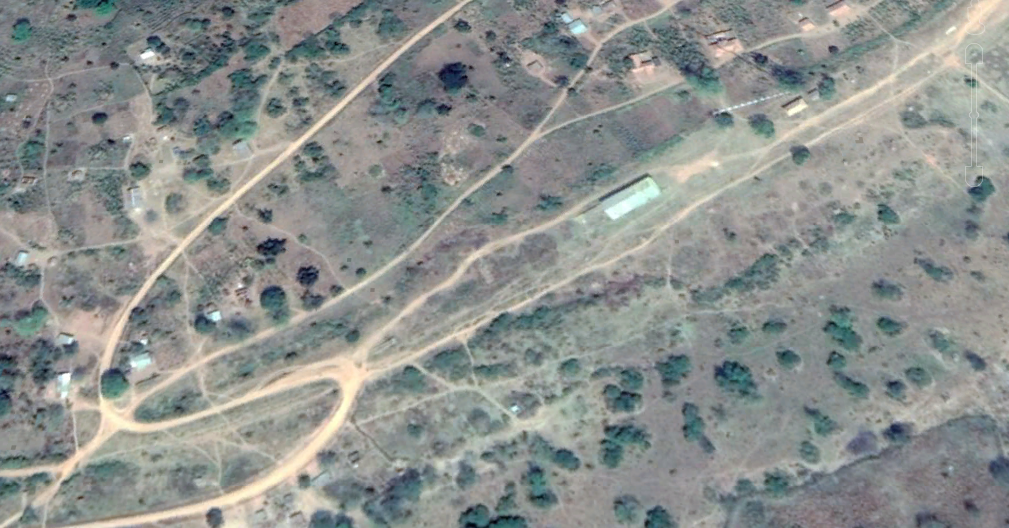
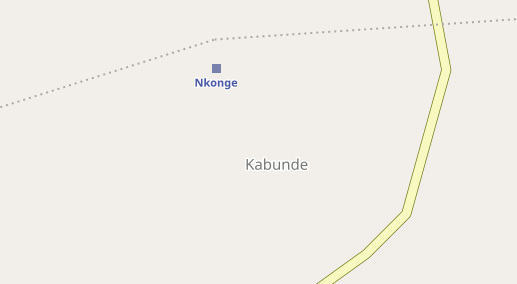 Nkonge and Kabagole are noted on the adjacent route map as the next halts on the line. Nkonge appears only on the most close up map view on OpenStreetMap, otherwise it appears as Kabunde. The railway line appears as a dotted line on OpenStreetMap but, while it is possible to identify the line on Google Earth, it is impossible to find the location of the station at the place marked on OpenStreetMap. In fact the most likely location is some kilometres to the west and I have chosen to show a satellite image of that location as the most likely location of the station.
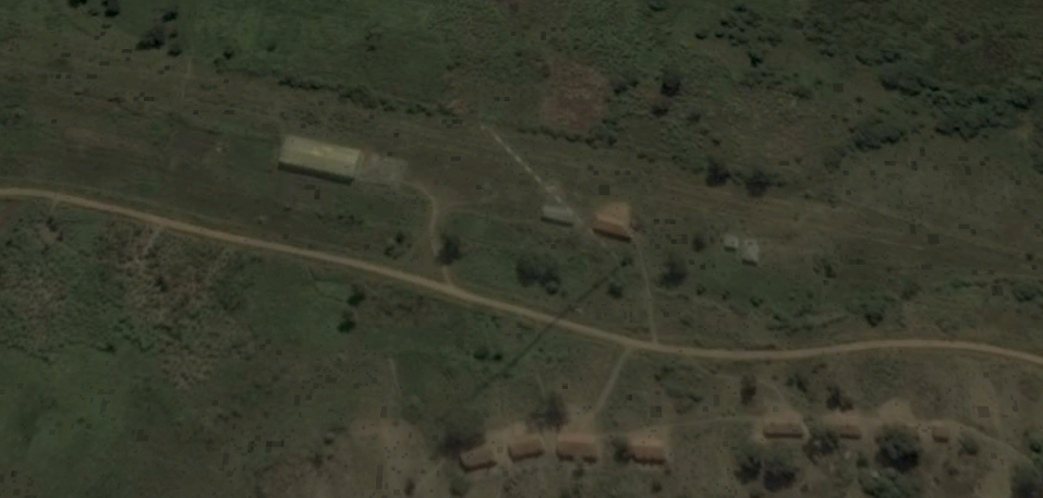 The railway route followed the swamp-filled channel of the Katonga River beyond Nkonge. Kabagole is also marked on OpenStreetMap close to the Katonga River.
 The quality of satellite images in this part of Uganda is poor. However, in our recent visit to Uganda (April/May 2018) we stayed for 10 days very close to the location of the station in a village called Kijongobya. We drove past the station location as we were leaving the location and had an evening close to the location in the Katonga Wildlife Reserve. Sadly, there is little evidence of the station on the ground and the line of the railway is difficult to identify. The story of those 10 days can be found elsewhere on this blog, along with pictures of the location as well, (rogerfarnworth.wordpress.com/category/uganda). [2]
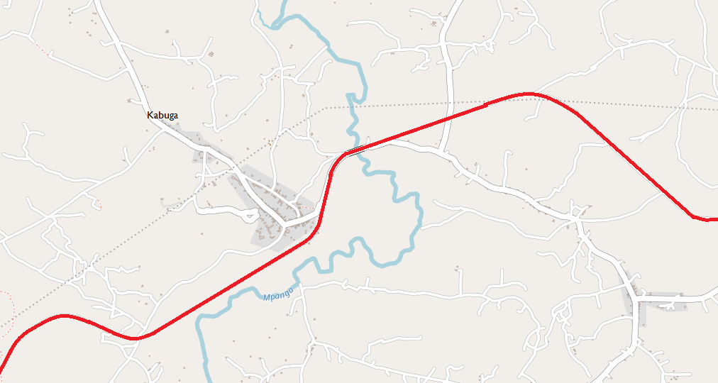
Next on the line comes Bihanga Station, at the Western end of the Katonga Wildlife Reserve and some 2 or 3 kilometres from the village with the same name. The satellite imagery at this end of the park is of very low quality and roads and railway lines are not distinguishable from the green of the countryside.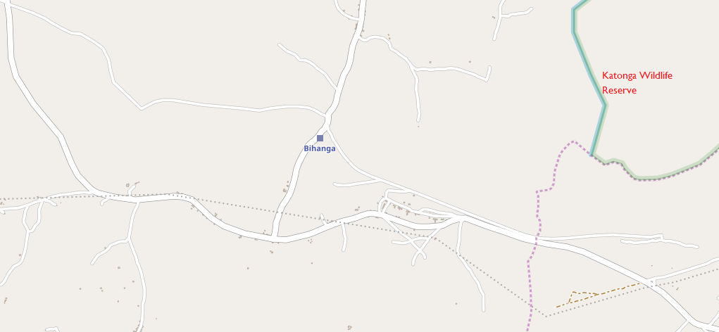 The line reached Kabuga – the railway line is shown in red. The station was probably to the west of the bridge over the Mpanga River. The road and the railway shared the bridge and the causeway to it.
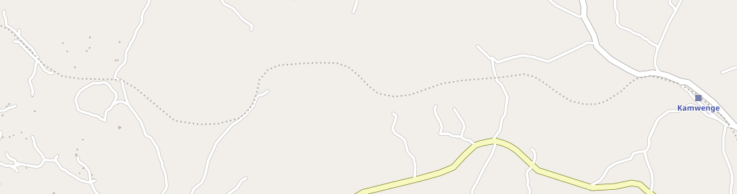
 From Kabuga the railway continued to Kamwenge. As elsewhere on the line from Kampala to Kasese, the line of the railway has sometimes been taken over by a road. This has sometimes happened by default and at other times as a result of planning by the immediate local authority.
The formation of the railway often provided a suitable ready formation for a road and usually for a road that would sustain heavier demands than other murram roads in the vicinity of the old railway.
The dotted line shown on some of the OpenStreetMap plans is an approximation to the route of the line rather than a detailed following of the route. This is evident on the plan of the area around Kabuga and continues to be the case between Kabuga and Kamwenge.
The actual route of the line is shown in red on the first map below. Travelling west, towards Kamwenge, the country becomes more hilly, the rainfall rises to 50 inches and the soils are of rather greater fertility. The land is of higher potential productivity than that the line has just travelled through, and around lbanda, twenty miles to the south, there is some relatively dense agricultural settlement: but the land near the railway was, in the mid-1950s, as yet almost entirely undeveloped, and very sparsely populated. [9] Kamwenge Railway Station was just to the northwest of the village.

 Recently laid track at Kamwenge, 172 miles from Kampala and the second last station before Kasese at Mile 208. Dura River at Mile 190 was the last station before Kasese, (c) James Lang Brown. [3]
From Kamwenge westwards the dotted line fairly represents the route of the railway which snakes around seeking to provide the shallowest possible grade through the topography of the West of Uganda.
The construction costs of the whole line from Kampala were very greatly affected by the difficult nature of the country in the final forty miles before Kasese. Severe problems were presented by the descent of the escarpment, which involves a spiral at one point, while from the foot there is an 18-mile crossing of papyrus swamp through which a causeway had to be built, entailing a vast amount of labour‘.

 Some of the EB1s ran in black and were duly converted to oil burners is shown here as a 22 and 24 Class haul empty ballast wagons along the extension, (c) James Lang Brown. [3]
Near Nkongora the topography necessitated that the line should gain height relatively quickly and to achieve this the engineers designed a spiral, the fourth on the line from Mombasa. It can be seen to the left of the map immediately above and in the image below. Aerial view of the 1.18% (1 in 84 approx) spiral which was cut round a hill between the Mpanga and Dura Rivers, (c) Brian Kingston. [3]

 The line wound its way westwards through the landscape to the edge of what is now called the Queen Elizabeth National Park and the bridge across the Dura River on the East side of the park.
The Dura River flowed through Queen Elizabeth National Park into Lake George and then to Lake Edward before becoming part of the Nile.
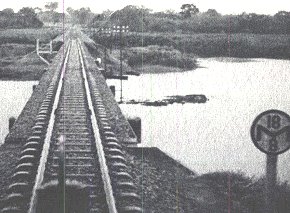 Crossing the Dura River Swamp (adjacent), (c) Geoffrey Parsons. The sign is a Momentum Board, which refers to the opposing gradient being steeper than the ruling gradient. The figures mean that the driver should achieve a speed of 18 mph at a distance of 4 furlongs (8 half furlongs) from the sign. The train’s maximum speed was 25 mph. [4]
After crossing the Dura River, the railway headed northwards until it reached Kitogo and then turned west following the northern border of the Game Reserve to cross 18 miles of swampland before encountering a branch line which served the Hima Cement works north-east of Kasese.
 Hima Cement Works near Kasese. [6]
The mainline continued to follow the northern border of the Game Reserve all the way to Kasese Railway Station. Kasese Station was not the end of the line, but we will look round the station before heading on.
 The arrival of the all classes all stations mixed goods train arriving at Kasese in the morning after leaving Kampala the previous evening. The main purpose of the line was to facilitate the export of copper from the mine at Kilembe There were great plans for Kasese and a grid of tarmac surfaced roads was laid out. But the roads, like the great plans led to nowhere, (c) Harry Dodge. [4]
 The Ruwenzori Range form a backdrop to the Class 60 Garratt as it leaves the train to take on water and head for the small motive power depot where a second Garratt has been stabled, (c) Harry Dodge. [4]
 Kasese station looking west towards the old loco shed and Ruwenzori Mountains beyond. It is midday and the pilot loco, 73u08, waits for the arrival of the overnight train from Kampala, which was due several hours earlier, 30th March 1984, (c) torgormaig on the National Preservation Forum. [16]
The picture immediately above shows the station at Kasese in relatively good condition. The photos that follow tell a very different story! Tracks laid in 1955 when the Western Extension was laid from Kampala to Kasese to service the copper mine at Kilembe and a few buildings are all that is left of Kasese station in the early 21st Century, (c) Roger Steedman. [5]
 Above, Kasese Humanist School taken across the tracks at Kasese MPD. [7].
Right, those same tracks being removed by the railway company. [12] A view from the station platforms towards the MPD with the Humanist School visible in the left background. [8] Various Station images follow. [15]


The opening of what was officially termed the Western Uganda Extension. A special train conveying the Governor, Sir Andrew Cohen, and HH the Kabaka of Buganda travelled overnight from Kampala behind a 30 Class locomotive which was named Batoro by the Omukama of Toro on its arrival at Kasese . The train is seen arriving at Kasese – the “defaced” blue ensigns are the official flags of the East African Railways and Harbours. The second coach back from the locomotive is a special vehicle which may have formed part of the “royal” train stock used by visiting royals and colonial governors of the time, © EAR&H Magazine, December 1956. [4]
The route of the line beyond Kasese Station is shown as a black line on the map below. The line first turned north and provided access to sidings for industry on streets to the north-wet of the railway station. It then turned sharply back on itself and travelled in a generally south-southwest direction. Immediately off the southwest corner of the map is the location of the Kilembe mines. The site is shown on the second map below.
 The immediate area around Kasese is shown on the satellite image below. The line of the railway can just be picked out entering the image in the top right-hand corner and running to Kasese. Kilembe Mine is shown towards the bottom left of the image close to the town of Kasese.
Kilembe Mines: In July 1950, two Canadian mining companies, Frosbisher Limited and Ventures Limited, formed a joint venture, named Kilembe Mines Limited (KML), whose objective was to mine copper from under the Rwenzori Mountains near Kasese. [10] KML built and operated a copper smelter in Jinja and maintained offices in Kampala, the country’s capital.
In 1962, KML was acquired by Falconbridge of Africa, who sold it to the Government of Uganda in 1975. Copper extraction ceased in 1982 due to dilapidated equipment, high inflation and insecurity. [10]
In 2013, after nearly 30 years of dormancy and after several failed attempts to privatize the mine, a consortium led by Tibet-Hima Mining Company Limited, won the competitive bid to manage, rehabilitate and operate Kilembe Mines Limited for 25 years from 2013 until 2038. In exchange for those rights, the consortium paid a cash down payment of US$4.3 million and is expected to make an annual payment of US$1 million until the end of the concession.
The consortium agreed to invest US$135 million into rehabilitating and improving the mine and to increase the capacity of Mubuku I Power Station to 12MW. In addition to the cash payments above, royalties were promised to the Ugandan government as were taxes on Kilembe Mines Limited business operations.[10]
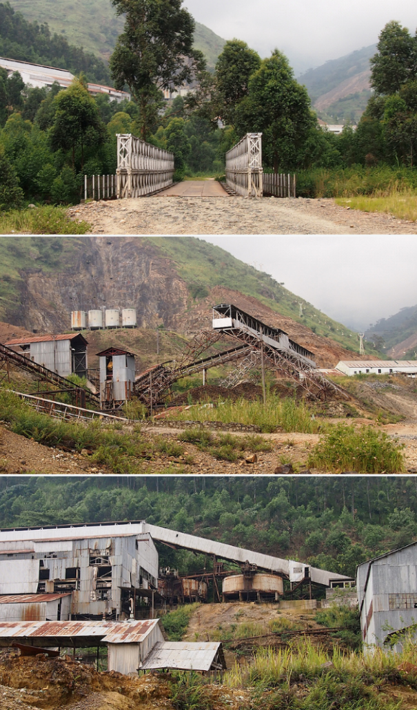
Sadly, little or nothing of this had materialised by July 2017. [11] And by the end of the year, the concession had been withdrawn by the Ugandan Government. Above, Kilembe Mines access tunnels, [13] and below, a view across the mine complex. [14]
 The following are a range of views of the Kilembe Mines site. [15]

References
- http://www.mccrow.org.uk/EastAfrica/EastAfricanRailways/EARIainMulligan/UgandaRailways2004.htm, accessed on 1st June 2018.
- https://rogerfarnworth.wordpress.com/category/uganda (26th April to 4th May 2018).
- http://www.mccrow.org.uk/EastAfrica/EastAfricanRailways/WesternExtension.htm, accessed on 9th June 2018.
- http://mccrow.org.uk/EastAfrica/EastAfricanRailways/UgandaBranches.htm, accessed on 1st June 2018.
- http://www.mccrow.org.uk/EastAfrica/Uganda/FortPortal/FortPortal.htm, accessed on 10th June 2018.
- http://www.theeastafrican.co.ke/business/Uganda-large-infrastructure-projects/2560-4033776-12y0h8yz/index.html, accessed on 10th June 2018.
- https://www.globalhand.org/en/search/451/request/6522, accessed on 10th June 2018.
- https://minbane.wordpress.com/2016/03/14/httpwp-mep1xtjg-1or, accessed on 8th June 2018.
- A. M. O’Connor; East African Studies No. 18; East African Institute of Social Research, Oxford University Press, 1965 p51ff, accessed via OpenDocs (https://opendocs.ids.ac.uk/opendocs) on 9th June 2018.
- https://www.newvision.co.ug/new_vision/news/1325495/chinese-kilembe-mines, accessed on 11th June 2018.
- http://allafrica.com/stories/201707030587.html, accessed on 11th June 2018.
- http://www.mysecretatheistblog.com/2013/07/the-rails-come-off-ugandan-humanist.html, accessed on 11th June 2018.
- http://ugandatourismcenter.com/place/kilembe-mines, accessed on 11th June 2018.
- http://allafrica.com/stories/201701100036.html, accessed on 11th June 2018.
- https://www.flickr.com/photos/caligula01/albums/72157633876140626, accessed on 11th June 2018.
- https://www.national-preservation.com/threads/uganda-railways.1150502, accessed on 12th June 2018.

Dear Sir,
First of all thank you very much for these informations. I have been in Uganda once early this year and the purpose of the visit was checking Kampala-Malaba metric line. I am a railway alignment designeer and most probably i will go once more for Tororo-Pakwach and Nalukolongo-Kasese lines to Uganda before Christmas. For Tororo-Pakwach i found some documents including a feasbility report via web but almost the only information that i was able to gathered about Kampala-Kasese are hereinabove. I like your blog and thanks once more. I have created kmz(google earth) files of all these three lines including chaines (as metric:), and it will be a pleasure to share with you.
One of the most critical things is accommodation for these kind of African trips as you know better than me. If you may kindly share some places to stay for both these corridors that will be higly appreciated.
Kind Regards
Oktay Çetin
Thank you taking your time to visit these railway lines. When do you think the line shall be rehabilitated
I am sorry Godfrey. I do not know.
I do know that the Ugandan government is looking at refurbishment of the lines East from Kampala provided funding can be secured.
Pingback: Uganda’s railway is not on track – – PEP FORUM – UGANDA
Really a deep study and well described.
In the 1980s when a new Government took over, they had made a request to Government of India to help Uganda to study and rehabilitate the Kampala – Kassase Rail line.
India agreed and I was deputed to Uganda and to study and make proposal to rehabilitate this important Rail connection
The situation in Uganda was not so very nice then – it was after the departure of Idi Amin , and all commerce and industries were in Shambles . Actually, from the airport to my Hotel In Uganda , I saw many armed troops stationed all along to maintain peace.
I met the GM of the Railway and the minister and after discussions , it was decided that I accompanied by the GM would travel in a Saloon to go over the section , discuss the issues with the GM and get all the clarification from him . We started the next day , there was an armed Soldier who was to accompany us to provide some(.?) protection
The train moved but had many halts in between . The terrain is undulating and passed mostly through sparsely populated areas,On the way we saw the Cement Plant ( not working then) which was set up by an Indian entrepreneur, but he had to abandon the country during Idi Amin regime . I believe he and many other Indians had invested a lot and were working the assets properly
We moved slowly with numerous stops. It took us 2 days and more to reach the outskirts of Kassese , it was noticed that the Soldier had disappeared and we had to make do on our own
We came back to Kampala and was to meet the Minister and other officials ( including the PM) This meeting was organised by Indian High Commissioner.
Basically my proposal was to replace the track with old released Indian materials and also to do up the bridges , stations etc so that the line could be rehabilitated. I had noted that the traffic on the line was very low and that even after allowing for the increase in it , the rehabilitated track would be suitable to carry the traffic well
Now, I had to face the barrage of questions from the Minister who seemed to have been agitated to hear that I have proposed old materials to be used. He wanted all new materials and was not at all mindful of the cost of new materials. Over all it was not a pleasant meeting
In India , I duly submitted my report . However nothing came out of it .
On reading your details , I wonder how things would have been if the proposal to use released serviceable materials had been agreed to . The rail line would have been running and going strong
Thank you for this story. It was a particularly difficult time in Uganda’s history. I know that as work has been attempted to rehabilitate the line to Gulu in the North, the condition of the line has been discovered to be very poor with lengths removed, presumably thefts for scrap metal value.
Do you have any photographs of your journey?
Pingback: 53 Eisenbahnmuseum PRIORI, die Reiseorganisation für Afrika